Walk Leader
Douglas Johnson
Capacity
10
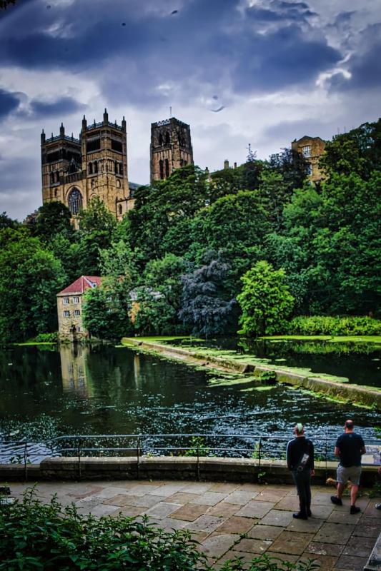
A walk around the Cathedral/Castle peninsula at river level from New Elvet Bridge to Framwellgate Bridge. A heavily wooded gorge - good autumn colour? Scullers and rowing eights on the river. Several fine bridges, ancient and modern. Views across river to Cathedral, Castle and other buildings. Approximate distance one and a half miles.
Although the walk itself is fairly level, you may wish to explore steep stairways off or vantage points in sometimes muddy areas off the path. Also the approach and exit points involve steep slopes. Sturdy footwear is recommended as is clothing appropriate to the weather conditions.
Once the walk is completed, you may wish to take advantage of the many photo opportunities in the compact and bustling city centre with its array of old buildings, alleyways, etc.
Walk Location
Durham City Waterside
Walk Directions
Meet at the equestrian statue in the Market Square - DH1 3NG / What Three Words: ///public.move.tanks
Durham has frequent rail connections on the East Coast Main Line from north and south. The descent to, or ascent from, the city centre is steep, but there is a bus service. Bus connections to Durham are also frequent from towns in the area.
If arriving by car, there are several central multi-storey car parks which charge by the hour. I usually use one of the three Park-and-Ride facilities for which you pay £2.20 for parking and travelling all day up to 7pm. Just off the A1M Junction 62 is Belmont (Service PR1). From the north or north west, Sniperly is on the A691, off the A167 at Framwellgate Moor (also Service PR1). To the south/southeast is Howlands off the A177 South Road (Service PR2). They all go to the Leazes Road Underpass at Milburngate Bridge which is a short walk from the Market Place.
Accessibility
While our walk is level, Durham is a hilly place with some steep roads and staircases. It is possible to access most places in a wheelchair but routes may be circuitous. The main walk is around one and a half miles.
Feedback Meeting Type
Zoom
Feedback Talk Date and Time